
The Extended NAWAPA:
Engineering the Biosphere
October 2011
This article appears in the October 14, 2011 issue of Executive Intelligence Review and is reprinted with permission. [PDF version of this article]
This report is based on an LPAC video, moderated by Hector Rivas, which is available on the LaRouche PAC website . It is part of a series being presented under the heading, “The Pacific Orientation: A New Global Strategic Policy Outlook.”
 LPAC
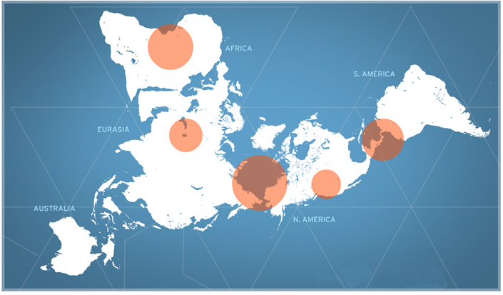
The Extended NAWAPA: The North American Water and Power Alliance—a massive bioengineering project centered on a Western Hemisphere watermanagement system—will expand to upshift the economic and infrastructure platforms of every continent on the planet, as merely indicated in this schematic. |
NAWAPA, the North American Water and Power Alliance, will be the keystone for a much needed nationwide recovery in the United States. It will employ millions of Americans in a great project, which represents more than millions of new jobs: It means employing mankind to act as co-Creator on Earth. The millions of currently unemployed Americans will embark on a great mission with this water project, to reorganize the functions of life on our North American continent, especially plant life, increasing the photosynthetic potential, transforming climates, and shifting existing weather patterns, which could have positive implications throughout the globe.
In this video presentation, we will focus on how, in a post-Obama world, NAWAPA will become a new standard for international cooperation. The vision, as proposed by Lyndon LaRouche and his science research team (“The Basement”), calls for an Extended NAWAPA, which will first, by intention of the original NAWAPA project,[1] bring us in cooperation with Canada and Mexico. However, the full extent of the international NAWAPA, will come into being through a leading initiative by a Three-Power Alliance among the United States—without Obama—Russia, and China.
With the initiative of these three nations, this new standard for international collaboration will extend into every continent of the globe.
We will now examine four specific projects, each representing a different region of the world. The case-studies begin with Africa, followed by Central Asia, Central and South America, and conclude with the development of the Arctic region. All of these regional proposals already exist on paper, awaiting execution. The only hold-up lies with us in the United States, and the implementation of a new Presidency. If the United States chooses to set the standard with NAWAPA here, under an international fixed-exchange-rate credit system, global development can finally become a reality.
Africa
Once the flow of hyperinflationary bailouts and financial mechanisms from the United States is dried up by the Glass-Steagall policy, Europe will then have no choice but to return to a system of individual sovereign nation-states, ending the euro system, and instead act together with a unity of principle towards the future. Then the challenge, in addition to the rebuilding of the nations of Europe, is the transformation of the African continent into a self-sustaining, integrated agro-industrial whole, capable of bringing its millions out of poverty. That will be the moral test for the nations of Europe, whose history of colonialism in Africa has brought about the most dire of circumstances on the planet. Today, the British empire still dominates that process, with other nations of Europe acting as junior partners in looting opportunities, fueled by environmentalist lies.
Figure 1 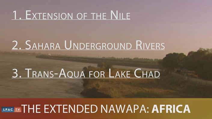 Three projects for Africa that could begin to provide urgently needed water for agriculture and the sustenance of human life.. |
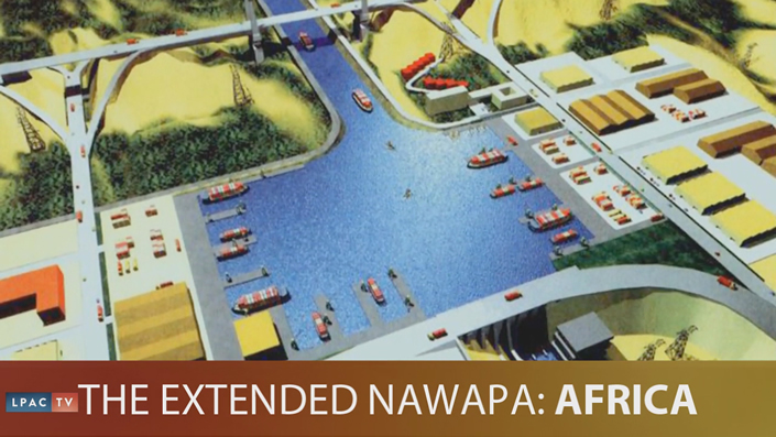 An artist’s conception of the new river to be created by the Transaqua project. It will create the first inland sea port in Africa.. |
With a United States dominated by policies in the tradition of Franklin Roosevelt, our nation’s foreign-policy will be geared towards facilitating the tendency, both in Europe and in Africa, towards continental development. This approach, as understood by Roosevelt, was the key to overthrowing British imperialism as personified by Winston Churchill. This would be done not through throwaway projects based on old, inadequate or green technologies, but through the integration of the continent of Africa as a whole, and the utilization of the most advanced technologies such as nuclear power, high-speed rail and maglev, and the most advanced agricultural techniques, irrigated by some of the largest water projects on the planet.
The process of the redistribution of water throughout the continent of Africa, in the same vein as NAWAPA for the Western Hemisphere, would have transformative effects on the climate globally. The introduction of green plant life where currently the ability to sustain life is not feasible, would have a profound effect on a deadly trans-Atlantic cycle of extreme weather, such as the devastating hurricanes we have recently experienced in the United States.
Three specific projects that could begin right away for the creation of abundant water for agriculture and the sustenance of human life, would be the extension projects along the Nile River, the channeling of the underground rivers of the Sahara, and the development of the Transaqua project for the replenishment of Lake Chad (Figure 1). The Nile is already harnessed with a series of dams and water projects, one of which irrigates about 2 million acres of farmland between the Blue and the White Nile. Since Sudan’s land is among the most fertile in the world, rapidly increasing the capability for irrigation could turn that nation into a breadbasket for the entire continent. The Jonglei Canal project, which currently lies incompleted, could be revived to rapidly expand this potential, diverting water that now runs into swamps, into the White Nile for agriculture.
Far to the west of the Nile are the barren salt flats of Algeria and Tunisia, under which exist ancient underground rivers, trapped in the sandstone waiting to be tapped. A massive underground body of water, the Mega Lake, exists in this area, equivalent to the size of our Lake Erie. This lake could supply water to thousands of wells across these two countries.
In addition to this, plans have been drawn up for reflooding of seawater into the salt flats of Algeria and the Quattara Depression, which would have a profound impact on cooling the climate of the region. Africa was not always home just to barren and dry climates. Lake Chad in the Sahel region was once the sixth-largest freshwater lake in the world, but is now drying up.
The Congo River, south of the Sahel, is the deepest, and the second-largest river in the world, by volume. As a result of the lack of sufficient development, it is often flooded. Rather than allowing this cycle of flooding to occur, Transaqua would create a new river that would divert water north through two catchment basins and into Lake Chad. The total flow of this new river would be 81 million acre feet per year, with the potential to produce 4 gigawatts of hydroelectric power.
The whole stretch of this new river would be 1,750 miles, about half the breadth of the United States, and will be on average 80 feet deep and 330 feet wide, making it navigable, and generating the first inland sea port in Africa. Once the water refills the Chad basin, new agricultural development will blossom in the region, covering 12-17 million acres of irrigated farming.
Today, Africa does not have the industrial capability and skilled labor to implement these massive projects. However, it would not take much time at all to end the problem of hunger, and bring in the necessary skills to industrialize and unify its nations. Europe, to the north, has some of the most densely industrialized centers in all the world. As part of a crash development program, Europe could apply its already existing skilled labor to assist in building these projects, thereby bringing to the young generations of Africa the means to overcome the legacy of colonialism in the decades to come.
A great power exists in Africa, among its people, and its resources. As President Franklin D. Roosevelt said, during the World War II Casablanca conference in Morocco: “Wealth! Imperialists just don’t realize what they can do, what they can create! They’ve robbed these continents of billions, and all because they were too shortsighted to understand that their billions were pennies, compared to the possibilities! Possibilities that must include a better life for the people who inhabit this land.”
The Aral Sea
Let’s look at Central Asia—another impoverished region, known for its extreme climate and severely arid conditions. Here, the developmental prospects, we can say, are numerous and long overdue. But for our purposes, let us take up the case study of the depleted Aral Sea.
 NASA/Zafiroblue05
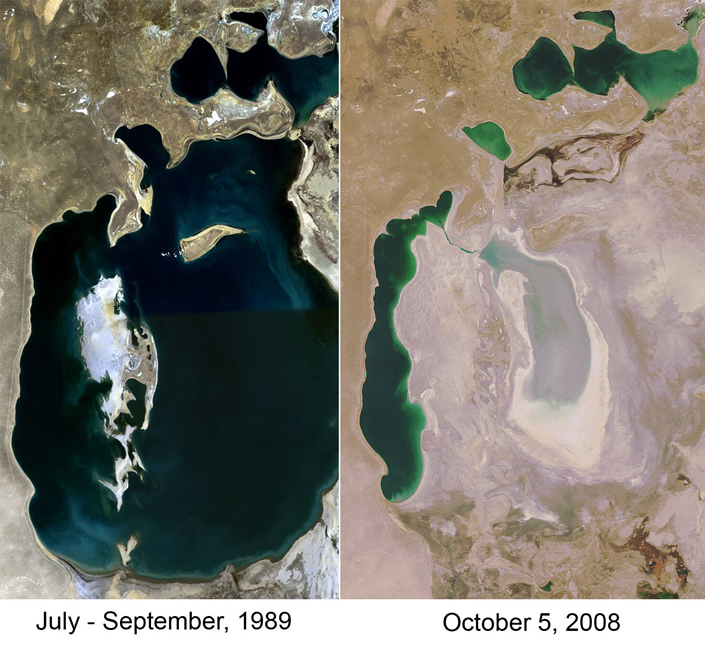
The Aral Sea Basin was once a reliable source of clean water and irrigation for the region. But decades of backwards monoculture, wasteful water diversion canals from the Soviet era, and subsequent free-trade policies, have acutely depleted the river systems which had fed and replenished it. The Aral Sea has shrunk to 10% of its original size. |
The Aral Sea Basin, a water system which reaches every country in Central Asia, was once a reliable source of clean water and irrigation for the region’s population. The Aral Sea itself, which was once one of the four largest lakes in the world, in addition to having been the source of a once-thriving fishing industry, also played a crucial role in climate moderation in widely parched Central Asia.
But decades of backward monoculture—specifically of cotton—wasteful water diversion canals from the Soviet era, and subsequent free-trade policies, acutely depleted the river systems which had replenished the Aral Sea. As a result, over the course of a few short decades, the Sea has now shrunk to 10% of its original size; and without the constant inflow of freshwater, it has become highly salinated, to the point where all 23 species of fish, that had once inhabited the Aral Sea have died off.
Today, the depleted Aral Sea Basin qualifies as a humanitarian emergency; not only is there a severe lack of freshwater for its dependent population, but, having been transformed from a large body of water into a salt wasteland, wind storms often pick up the salt and pummel the surrounding areas of Kazakstan, Uzbekistan, and Turkmenistan, making agriculture increasingly difficult, and harming human health. Life expectancy is shorter, the closer you live to the Aral Sea. The child mortality rate is 75 children per 1,000 newborns; and in the Karakalpakstan region, the epicenter of the crisis, a high level of maternity deaths—120 women per 10,000 births—is observed.
 Today, the depleted Aral Sea Basin qualifies as a humanitarian emergency. The child mortality rate in the the region is 75 children per 1,000 (for comparison, the U.S. rate is 65 per 100,000). |
In addition, due to increased salt storms and the exposure of food and people to water and air that are increasingly contaminated by harmful levels of salt and toxins, diseases such as tuberculosis, infections, and parasites, typhus, hepatitis, and paratyphoid, have dramatically increased. According to a 2002 UN estimate, every day 200,000 tons of salt and toxic sand are carried by the wind throughout the Aral Sea region and thousands of miles beyond, sometimes reaching as far as Russia’s Arctic North.
No doubt, this is a truly ecological and humanitarian crisis. The issue that we must confront is that this was a disaster directed by policy. After more than a century of backward agriculture, and resource and human exploitation, culminating in today’s system of globalization and cheap slave labor, the Aral Sea crisis is the result of a deliberate downgrade of the region’s Biosphere and people.
With the removal of Barack Obama from the Presidency, the re-enactment of Glass Steagall, and the implementation of an international fixed-exchange-rate credit system led by the United States, we can effectively push back the imperial policies which had ruined entire regions like Central Asia, and extend to them the NAWAPA perspective.
Like NAWAPA, designed for North America, and the Transaqua irrigation project for Africa, reviving the Aral Sea and upgrading Central Asia in general will be a monumental endeavor, bound to test the limits of human ingenuity.
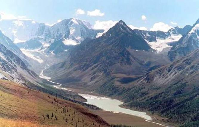 A project proposed in the 1940s by Russian engineer M.M. Davydov to replenish the Aral Sea would bring water from the Altai Mountains (shown here), the source of the Ob and Irtysh Rivers.. |
One proposal which we here at LaRouchePAC have highlighted is a project proposed in the 1940s by Russian engineer M.M. Davydov, and since modified, to replenish the Aral Sea, by way of water diversion from a source thousands of kilometers away, in the Altai Mountains, seated where Russia, China, Mongolia, and Kazakstan all meet. This area has anomalously high precipitation, and is the source of the Ob and Irtysh rivers, both of which run westward, and meet before they drain off into the Arctic Sea. The proposal calls for damming the Ob and Irtysh where they meet, saving 8% of the runoff water that would otherwise go into the ocean, to create a reservoir of freshwater. The water in the -reservoir would then be channeled via a 2,550-kilometer-long canal, lifted a total of 300 feet through a system of six pumps, and then, into the Aral Sea it goes!
With the Aral Sea replenished, fishery can be rejuvenated. Agriculture can be expanded to produce for Eurasian and Russian consumption, as 4.5 million hectares of irrigable land is made available. In general, life in the region will be made more pleasant with the cessation of salt dust storms; and the vast greening process will surely moderate the region’s extreme climate conditions.
Furthermore, the transformation of the Aral Sea could be coupled with other development projects in the region, such as additional proposed canal and transportation corridors. For example, this process will be dramatically augmented in the context of bridging the Bering Strait. A series of new northern rail lines and corridors will connect our newly replenished Central Asia, with a North America freshly transformed by NAWAPA; and with a commitment between our friends to the South, and a new Presidency here in the United States, this international connection can reach the tip of Argentina uninterrupted, with the taming of the Darién Gap.
The Darién Gap
Today, an appendage of the British Empire known as the World Wildlife Fund, which is committed to a genocidal policy of population reduction, is a major impediment to development in every part of the planet. Currently, the area encompassing the Darién Gap, spanning the border between Panama and Colombia, (Figure 2) is deemed a Biosphere reserve that cannot be traversed by road or rail, and is now used by narcoterrorist armies for drug-trafficking, murder, and kidnapping. However, with the devleopment of the Darién Gap region, it will become possible to put an end to this plague of British imperialism for good.
The Project
Figure 2 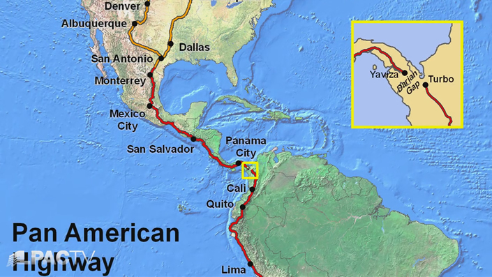 The bridging of the Darién Gap linking Panama and Colombia, by completing the 62-mile Pan-American Highway, is a key feature of the World Land-Bridge. |
The first step of the program would be to complete the 62-mile Pan-American highway connection between Yavista, in Panama, and Chigaroro, Colombia. American engineer and LPAC collaborator Hal Cooper has already proposed three possible routes: one through the wetlands; a second along the Eastern coast, and third, a bridge over the Gulf of Uraba. In each case, the terrain provides enormous challenges.
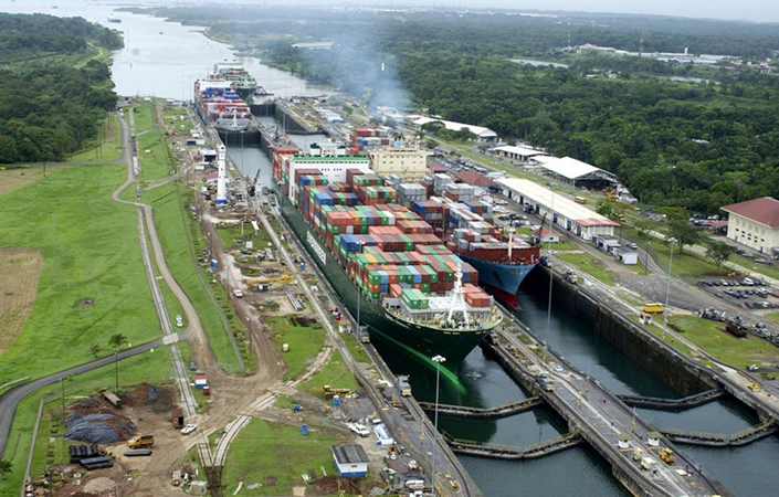
Currently, the only way to ship goods through the region, is through the Panama Canal, which is already inadequate to handle the volume of shipping, and will become more so, with the planned upshift global development. Thus, a second canal must be built.
The projected Atrato-Truando Canal is one of several possible routes. It would utilize part of the Atrato River in Colombia, and the rest could be created by using peaceful nuclear explosions.
Next, the Colombia and Venezuela rail lines will need to be extended and upgraded with maglev, particularly to handle those high-altitude mountain ranges. The Peruvian, Bolivian, and Brazilian rail systems will also be upgraded. All of these will then be linked to a new Argentina-Chile rail system, which will then extend down into southern Patagonia.
This grid will supplement the integration of the three major river systems of the region: the Orinoco, the Amazon, and the Rio del la Plata.
Changing the Biosphere
 Creative Commons/whl.travel
Plans for a second Panama Canal have been on the books for years. Now, with the Extended NAWAPA, they can become a reality.. |
This region has been transformed by the hand of man before. It has been shown that in the last 12,000 years, astronomically advanced societies terraformed thousands of square miles of the Amazon region. These early civilizations used advanced agricultural methods to engineer a highly fertile black soil in as much as 10% of the Amazon, an area about the size of France!
It’s a known fact that cloud formation in the Amazon is heavily affected by vegetation on the Earth’s surface, and that this, in turn, affects weather patterns, not only in the region, but around the globe.
By reintroducing the hand of man as gardener and terraformer in this region, we will come to better understand how the entire Biosphere functions and perhaps craft new weather systems for the benefit of man!
Resources and Space
 NASA
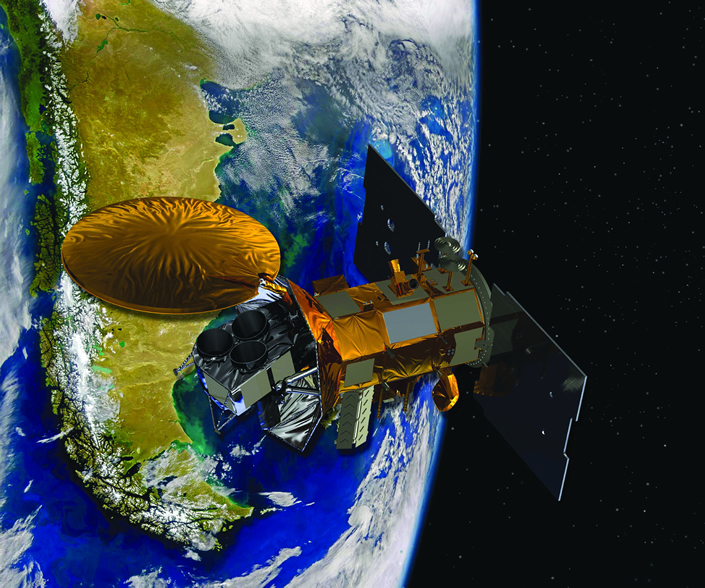
Space is the next frontier for the nations of Ibero-America. The best place for rocket launches is near the Equator, for example, in Alcantra, Brazil. Shown: an artist’s concept of the Aquarius- SAC D spacecraft, a collaboration between NASA and Argentina’s space agency.. |
Finally, there are vast mineral deposits throughout the region, including iron, copper, nickel, and plenty of uranium to fuel new nuclear power plants, which currently only exist in Brazil and Argentina. Given the right kind of economic development, with these vast resources and the already existing capabilities therein, Argentina, Uruguay, and Brazil could be the productive axis that could develop the rest of the energy needs of South America.
Argentina’s and Brazil’s activity, in particular, should be directed toward space. For instance, the best place for launching rockets into space is near the Equator because that is where there is the greatest angular momentum. And in fact, Alcantera, Brazil is currently home to the closest launch center to the Equator; and Argentina already has the beginnings of a significant aerospace sector.[2] Breakthroughs in rocket fusion technology, and astrobiology field work (which is already being pursued in Chile) could become commonplace in the region. Moreover, given the proximity of the South Pole, the study of the Aurora Australis becomes increasingly relevant as we enter into this heightened global period of disturbances caused by extraterrestrial electromagnetic activity.
The Arctic Region
Throughout the last several hundred million years, the Earth has been subject to a number of glaciations. Roughly 20,000 years ago, during the last glacial maximum, the land currently beneath the Bering Strait was exposed, due to lower sea levels caused by much of the ocean water being locked up in icecaps. This passageway once provided an overland transport route for both human beings and animals. The warming trend that began at the end of the last glaciation period, around 10,000 years ago, flooded the area and severed this land connection. Today, we have the option of connecting it once again.
 Council for the Study of Productive Forces (SOPS), Russia
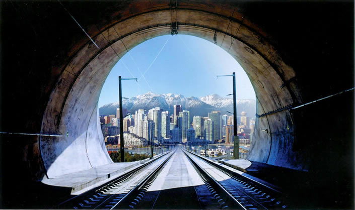
The project of building a bridge across the Bering Strait is not for the faint-hearted. The Strait spans 55 miles of the most hostile climate to life on our planet. But it will be done. Shown: an artist’s concept of the Bering Strait tunnel looking toward an new city.. |
The project of building a bridge across the Bering Strait is not for the faint-hearted. The Strait spans 55 miles of the most hostile climate to life on our planet. There are windchills that drop the temperature to near -100°F; and, eight months out of the year, the Strait is covered with ice floes, which can be as heavy as 250,000 tons.
The Bering Strait Bridge would be the longest bridge ever designed. Its 55 miles would be almost double the length of the longest bridge on the planet today—the Lake Pontchartrain Causeway, just outside New Orleans. The Causeway is 24 miles long, and runs through a moderate climate, and over calm waters.
The existing plans for the Bering Strait passageway are to incorporate a double-tracked, electrified rail line. This will either be in the form of a bridge or a tunnel. The passageway will cross both the Little and Big Diomede islands. Accompanying the rail line will be a paved road, a gas pipeline, and an electric transmission line. This bridge would support over 150 trains a day.
The challenges posed in the construction of the Bering Strait Bridge are conquerable, if we choose to do it. And, that is a good thing, because the bridge is only one of the critical parts of the extended NAWAPA program in the Arctic.
The Challenge of Siberia
Next, is the challenge of overland transport. The nations that surround the arctic are Norway, Denmark, the United States, Canada, and Russia. The Bering Strait Bridge will connect two continents, North America and Asia. But, simply building a bridge to modern-day Siberia, by itself, is not the point. Instead, the connection will serve as a critical junction point between the two sides of the Great Pacific Region. Russia covers 17 million square kilometers and 11 time zones. Siberia is a behemoth: At 13 million square kilometers, it is almost one third of the entire area of Asia, and its harsh weather makes it a substantial challenge to any overland transport development. For centuries, Russia has faced the challenge of how to develop and populate Siberia with cities and industry, or, whether to use it merely for extraction of raw materials.
In the late 1800s, with the construction of the Trans-Siberian Railroad, more people began to move beyond the Ural Mountains, and into the vast Far East—starting the first Siberian industry. During World War II, after the invasion by Hitler, Stalin moved thousands of manufacturing plants behind the Urals. Siberian development continued from 1950s through the 1980s, but since the breakup of the U.S.S.R., and the adoption of radical free-market economics in post-Soviet Russia during the 1990s, the area has suffered a significant depopulation.
| Figure 3 Population Density: Siberia vs. the U.S.A. 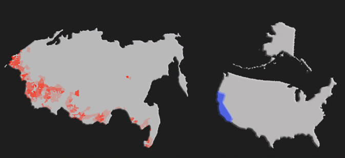 Siberia is a behemoth: 38 million people, only 26.5% of the population of the Russian Federation, live in the area from the Ural Mountains eastward—77% Russia’s landmass. This image compares the size and population density of Siberia to that of the U.S. Siberia’s entire population could fit into the state of California. |
Today, 38 million people, only 26.5% of the population of the Russian Federation, live in the area from the Ural Mountains eastward, including Siberia, which encompasses 77% of Russia’s landmass (Figure 3). In order to support human life, and attract people to live in the area, certain economic preconditions will have to be met. Russia has already started planning new rail lines in the Far East, with a new 970-mile line extending from Tynda, on the Baikal-Amur Mainline (known as the second Trans-Siberian Railway), to Yakutsk, the capital of the Sakha Republic-Yakutia, and then on to Magadan on Russia’s Pacific Coast (Figure 4). The extension of this track to Uelen on the Bering Strait is to be completed by 2030, totalling up to 2,500 miles of track. With a United States under NAWAPA, working with Russia, this timescale could be reduced dramatically.
This transport build-up must occur in conjunction with development of science centers along the existing Trans-Siberian route. One such critical center is the Vostochny Cosmodrome. The spaceport, which will be completed in 2018, will be a launch site for the Russian space program. It will be located along the Baikal-Amur Mainline, and surrounded by electricity-generating plants.
The Amur Region, with the Cosmodrome, is at the hub of Asia. It sits along Russia’s border with China, and has rail access to the Far East cities of Khabarovsk and Komsomolsk-on-Amur, as well as the port city of Vladivostok. The rail lines of Russia, China, Japan, and North and South Korea will be connected to the Trans-Siberian line. With the line from Tynda through to Uelen, and the Bering Strait Bridge completed, this bloc of powerful nations will be connected to the United States, and Canada as well. This Great Pacific region will be the new center in the world—with 3 billion people and growing, as well as huge amounts of natural resources.
| Figure 4 The Baikal-Amur Mainline and Trans-Siberian Rail Line 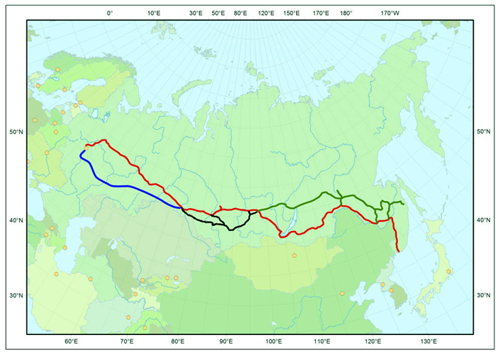 Russia has already begun planning new rail lines in the Far East, with a 970-mile line extending from Tynda, on the Baikal-Amur Mainline, to the city of Yakutsk, and then on to Magadan on Russia’s Pacific Coast, where it will reach Uelen, on the Bering Strait. The project will be complete by 2030. |
Vast Natural Resources
The Arctic is rich in untapped potential. Siberia, alone, contains 90% of the world’s palladium, 80% of its tantalum, 40% of the platinum, 36% of the nickel; and the list goes on. These minerals, plus petroleum, are already used for energy production, fuel cells, chemical manufacturing, and medicines, such as in the chemotherapy drugs oxaliplatin and carboplatin. This is without mentioning their future importance under a science-driver policy like NAWAPA.
One of the major engineering challenges of building in the Arctic, is the ability of the machinery to resist breaking and corroding, due to the temperatures and snow. Tantalum, a metal which has an anti-corrosive property, will be critical in experimenting with new metal alloys that can resist buckling from exposure. Platinum is a metal which might have extra-terrestrial origins. It is found in limited areas on Earth, and in greater abundance at large body impact sites, such as the Sudbury Basin in Canada. Platinum is found in the craters created and affected by what is termed post-impact volcanic activity. We know that it is also found in higher quantities on the Moon.
The Arctic Ocean floor is also a hotspot for hydrocarbons. All of the Arctic nations have claimed territorial rights to the North Pole region for shipping; and, for the untapped wealth of the sea bottom. Russian explorers, in a recent trip to the North Pole, just planted their flag on the bottom of the ocean. And, in a joint effort by the U.S. Geological Service and the Canadian Coast Guard, exploration and data about the nature and boundaries of the continental shelf of the Arctic is being collected as well.
Overall, the data from the U.S./Canada study estimates that the area north of the Arctic Circle accounts for an estimated 13% of the undiscovered oil, 30% of the undiscovered natural gas, and 20% of the undiscovered natural gas liquids in the world. The large amount of hydrocarbons in this area will be a generous source of energy in the future. But, while it plays this important role, this region also raises much more significant questions about the nature of life. And, this is what makes the Arctic the most important feature of the Extended NAWAPA.
The floor of the Arctic Ocean is a marine desert. In the deep waters, which are under perpetual ice cover, there is very little or no photosynthesis. And, with little organic matter coming from anywhere, life is more sparse than on other ocean floors. But, life has evolved without photosynthesis, from the methane and hydrogen sulfide which seep from the bottom of the Arctic. There are many species of organisms that have bacteria inside them, which can consume the methane and hydrogen sulfide, and generate energy from chemosynthesis.
 NASA NASA A NASA team of polar researchers drilled deep into the ice sheet at the South Pole, where, to their surprise, they found a Lyssianasid amphipod, a distant relative of the shrimp, alive and well, under the surface. If life can survive there, might there not also be life on Jupiter’s ice-covered moon Europa? |
There is another source of energy besides the vents. In 1995, a team of American, Norwegian, and Russian scientists found the active cold-seep mud volcano in the Barents Sea. They noticed thin white blankets, drapped over rocks and piles of sediment. These white blankets were colonies of millions of bacteria, which live on these sediments, digesting the organic matter in them, and producing methane as a by-product. In the seeps, methane, dissolved in the water, bubbles up through the ocean, and is ingested by the bacteria.
One of the most recent finds of life actually occurred at the other pole. A NASA team of polar researchers drilled a deep hole into an ice sheet, expecting to test their ice-drilling techniques. To their surprise, they found a Lyssianasid amphipod, a distant relative to a shrimp, alive and well in sub-freezing, dark water, 600 feet under the surface of an ice sheet, and 12 miles from open ocean. The scientists made a correlation, that if life can survive here, it is possible that it exists on Europa, a moon of Jupiter, whose surface is also covered by a sheet of ice, and should have similar conditions to the poles of the Earth.
From the North Pole to Mars
 Man will travel to Mars, but before we can get there, we need to answer a number of questions about what makes the Earth suitable for life. In Figure 5, the polygonal patterns, caused by water freezing and unfreezing, characteristic of Arctic permafrost, are also visible on the Martian surface. |
| Figure 5 Polygonal Ground Patterns on Mars Surface 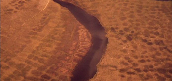 |
Today, there are isolated U.S. and Russian research stations in the Arctic, some floating on ice floes, and others deep inland, sitting on tundra. These North Pole stations carry out complex year-round research in the fields of geophysics, hydrochemistry, hydrophysics, and marine biology. They experiment with the magnetic field and the ionosphere. They take regular measurements of the ice floes to keep track of the direction and speeds. The modern drifting ice station resembles a small settlement with housing for polar explorers and special buildings for the scientific equipment. Usually, one of these stations begins operations in April and will continue for two or three years until the ice floe reaches the Greenland Sea. Scientists and explorers are rotated yearly.
Man will travel to Mars. And, if we are going to make it, and survive, we must know how to keep life alive in outer space, and on the planet, itself. Before we can get there, we still need to answer a number of questions about what makes the Earth suitable for life. As of now, we know that the atmosphere plays a protective role; on Earth, the atmosphere is a dense mix of oxygen, nitrogen, carbon dioxide, and water vapor. In comparison, the Mars atmosphere is less dense, made up of mostly CO2, which is currently thought to be unsuitable for animal respiration, but is suitable for plants.
Magnetic fields have an effect on life. The poles of the planet are a good place to test this relationship. The magnetic field on Mars is weak, and not unified across the planet. The temperature extremes are an important factor as well. In the Arctic, during the Winter months, the temperature can approach -100°F with windchill. The temperature of Mars varies between 70°F at the Equator to -200°F at its poles in Winter.
And, finally, notice the polygonal ground patterns (Figure 5), which are characteristic of the permafrost in the Arctic. These patterns come from water freezing and unfreezing, causing cracking in the surface. These polygonal shapes are also visible on many parts of the Martian surface. Building on the permafrost will do more to prepare us for facing the surface of Mars, than any Mars Analog Research Station will.
The challenges that humanity faces in the Arctic, will help to prepare us for engineering the Martian surface. We must take advantage of the unique characteristics provided to us by Earth’s North Polar region—the Arctic. The power of man is limitless, with the collaborative effort of Russia, China, and the United States under NAWAPA.
[1]. NAWAPA was conceived in the 1950s by the U.S. Army Corps of Engineers as a “Great Project” to develop more water sources for the United States. In 1964, the Ralph M. Parsons Company, a West Coast-based international engineering firm, presented a developed plan for NAWAPA to a special subcommittee of the U.S. Senate chaired by Sen. Frank Moss of Utah. As entered in the Congressional Record, the original NAWAPA plan called for no fewer than 369 separate projects.
[2]. See “Why London Finds Argentina ‘Odious,’ ” EIR, Oct. 7, 2011.