
Developing Siberia’s Raw Materials:
An Adventure for the 21st Century
by Dr. Sergei Cherkasov
September 2010
|
Dr. Sergei Cherkasov told the conference that the development of Siberia will not only benefit Russia, “but the whole world. Because Russia has a great stock of mineral treasures.” |
This article appears in the October 15, 2010 issue of Executive Intelligence Review and is reprinted with permission
Dr. Sergei Cherkasov addressed the Schiller Institute’s Berlin Conference on September 25. He is a geologist and Scientific Coordinator at the Vernadsky State Geological Museum of the Russian Academy of Sciences, in Moscow. His remarks were accompanied by a PowerPoint presentation; we publish here an edited transcript, with some of the graphics.
First of all, I would like to thank the organizers for the opportunity to talk here in Berlin. Last time, I had a similar experience in Kiedrich [2007], it was quite impressive. So, thank you Helga, thank you, guys.
Right before the break, we heard very poetic and very precise words about an infrastructure corridor going to the Bering Strait. I’m a geologist, so right now, I would try to marry the poetical and numerical approaches, with some of the common sense of a geologist.
First of all, we will look at the infrastructure projects that were either accomplished in Russia, or not accomplished, and we will try to understand what the signs are of a successful project, and where the faults were that prevented us from accomplishing such infrastructure projects. Also, since most of the load carried on the railways is provided by the mining industry, we will look a bit at the mineral resources for the area, where we are going to see, in the future, this infrastructure corridor. And then, we can discuss the results.
|
FIGURE 1 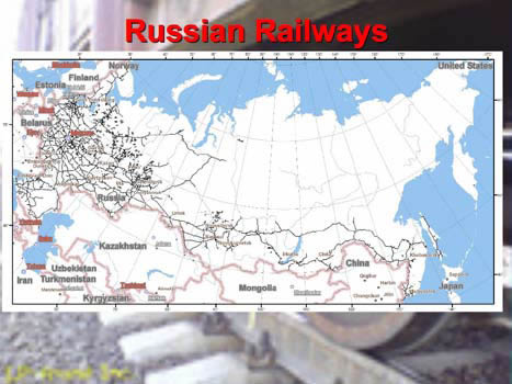 |
|
FIGURE 2 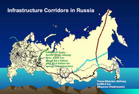 |
Figure 1 shows the currently existing Russian railways. You can see the European part, and the Trans-Siberian Railroad, and what we call the Baikal-Amur Mainline. And you can see this strange appendix going to western Siberia. What is also important, here, in the north, is a small railway, in the middle of nowhere.
With more or less detail, we will look at the history of the Trans-Siberian Railroad. It was under construction from 1890 to 1916, twenty-six years. Construction on the Baikal-Amur Mainline began in 1933, also a long time ago, when the Stalin government decided to build the Baikal-Amur Mainline, and it was completed just seven years ago. The next project is the Industrial Urals-Arctic Urals project, which started in 2003, and right now, its perspective looks quite pessimistic. And also we will say a few words about the North Seaway, which, in fact, has been under construction, from time to time, starting in 1915.
In Figure 2, the green dotted line, shows Industrial Urals-Arctic Urals, this new project; and this is the approximate route we are talking about with the new infrastructure corridor to the Bering Strait. The blue line shows oil and gas pipelines; and in dark blue, the Northern Seaway, which was widely used through the Soviet period. It worked a lot during the Second World War. Many transports from the United States went to Russia through this seaway.
The Trans-Siberian Railroad
|
FIGURE 3
|
|
FIGURE 4
|
We will start from what is maybe the most successful (Figure 3), the Trans-Siberian Railroad. If you look at the history, it was first proposed in 1857: The governor of Eastern Siberia proposed that the government establish such a project. It was, I think, too early. And only by 1890, did the decision of the Russian government become positive. Of course, there were different reasons for taking such a positive decision: First of all, in the Russian Empire, the Far East and Siberian territories were already more or less populated, but the trip from Moscow to Vladivostok took no less than three months. So, any mail, anything that had to be delivered, took three months minimum, sometimes up to five to six months.
And, of course, the Empire was worried about keeping these territories within Russia, so the connection was absolutely necessary. So, from one standpoint, it was a political decision; from another standpoint, as you see on this old map, there are towns that already had some industry—maybe not a lot, but some. There was already a reason to connect these towns, so they could transport goods and people from town to town. You can approximately evaluate the scale: The distance between Krasnoyarsk and Irkutsk, in the south, at the end of Lake Baikal, is about 1,000 km.
So, when we talk about the Trans-Siberian Railroad, sometimes people say, “It goes from Moscow to Vladivostok; it is nearly 9,500 km.” But, in fact, when we talk about the railway which was built from 1890 to 1916, it goes from Chelyabinsk—in fact, from the Urals—to Vladivostok, and it is nearly 7,000 km long. It took 25 years.
The railway was built in three stages. On the lower part of the graphic, you can see the first stage marked in red, the second stage in yellow, and the third one in green. You see that, in fact, the railroad was started from the two ends: from Vladivostok northward, and from Chelyabinsk eastward. And you see that the most difficult parts of the railway, the green areas, around Khabarovsk and what we call Circum-Baikal Railroad, were left for the future, because these areas here are very difficult to build in. There are mountains, large rocks, landslides, as we shall see later.
So, this was planned, and it was estimated that the whole work would cost 350 million rubles. What did that mean, in 1890? The only indication I can give you, is that the price of a cow was about 5 rubles. So, this is 70 million cows!
Figure 4 shows the first train arriving in Irkutsk on Lake Baikal. The map shows the years during which different parts of the railway were built; officially, it is believed that construction began with the first stone laid in the railway station in Vladivostok, which was in 1891. And you see, from 1892, what we call the Ussuri Railroad was built in four years; the West Siberian Railroad was built to Novosibirsk in four years, and then, to Krasnoyarsk.
There are many stories about this construction: For example, here you see a town, Tomsk. Tomsk was not a small town; it had a university, industry. I cannot say for sure whether it is true or not, but I have many friends there, and they told me, that at the time this railway was in progress, Tomsk businessmen decided against having the railroad pass through Tomsk. They believed it would be better to stand aside. So, people say that they bribed somebody in the government, and the railway went 400 km south of Tomsk. (By the way, Novosibirsk, which is now very well known as an academic city, as an industrial center, at this time was a small village, Novonikolayevka. And I think if the railway had gone through Tomsk, Novonikolayevka would have stayed the way it was. But now it has developed into a city of more than 1 million population, and Tomsk has stayed as it was! But it’s a very nice environment: a University, a lot of students, everything very peaceful, nobody hurries. It has some charm.)
[Dr. Cherkasov shows historic photos of the Zabaikal Railroad, going eastward from Lake Baikal.] For a long time, before they started to build the Circum-Baikal Railroad, they used to transport cars from one side of Baikal to the other. In the Winter, they just put rails on the ice—it worked like that for about ten years. And in the Summer, they had a ferry which would take the cars, one by one, from one side to the other.
|
FIGURE 5 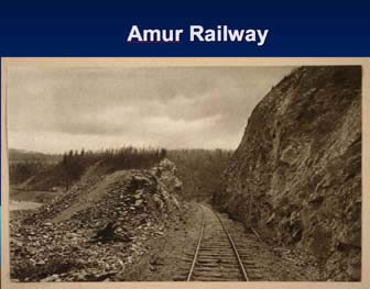 |
FIGURE 6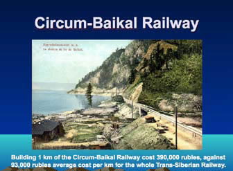 |
|
FIGURE 7 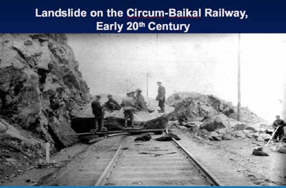 |
|
FIGURE 8
|
Figure 5 shows the Amur Railroad, going through a mountainous, rocky region. And Figure 6 is what I told you about: the Circum-Baikal Railroad: You can see, all the way, it goes between the coastline and hard rocks. The average price for the whole Trans-Siberian Railroad was 93,000 rubles, or about 18,000 cows, per kilometer; but this part was 390,000 rubles, nearly five times as expensive, because of very difficult conditions. Figure 7 shows one of the landslides that happened from time to time.
The Trans-Siberian Railroad was divided into four parts, in terms of management (Figure 8). These were the Siberian Railroad, shown in blue; the Zabaikal and Circum-Baikal Railroad, in green; the Amur Railway, in red; and the Ussuri Railroad, in yellow. Right now, the Trans-Siberian Railroad carries about 100 million tons of freight per year, and they say that more is just impossible. It is absolutely 100% loaded and working at full capacity.
So, what we can conclude from the history is that, first of all, of course, its construction was a matter of political will, to build such a railroad. It was, secondly, an economic necessity. Because, even if it was impossible to build all 7,000 km in a few years, separate parts of the railroad connected industrial centers. They already started working. Along the route of this railroad, we have quite a lot of mineral deposits, and a lot of them would never have been developed without the proper access, without good transportation.
And, of course, we can only admire the ability and talent of those who constructed this. Can you imagine, nearly all this railway, excluding the Circum-Baikal Line, was done, actually, by hand—without any machines! In such conditions, at the end of 19th and beginning of 20th centuries. It is really a memorial to the people who built this. I would say, it’s a Wonder of the World.
Development of the Arctic Region
|
FIGURE 9
|
|
FIGURE 10 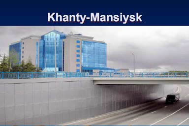 |
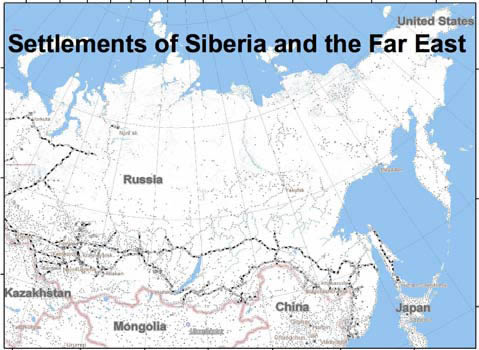
Let us look at what we have now (Figure 9. The small dots show the settlements: villages, towns, and so on. I think we can try to define three different ranks of settlements: First of all, towns with industry. Norilsk is an example of such a town, which is located above the Arctic Circle. Its population is a bit over 100,000 people. It’s near a huge nickel and platinum element deposit. They have, of course, a huge metallurgical factory.
A similar town, but located south of the Arctic Circle, at Parallel 61 (as you know, the Arctic Circle is at 68 degrees, so it is about 600-700 km south of the Arctic Circle, in western Siberia), is Khanty-Mansiysk (Figure 10). Khanty-Mansiysk is beginning to look right now, almost like Shanghai. It is located in the middle of an oil and gas province, and the amount of money involved is so huge, that in the middle of western Siberia, we see such buildings: This is the office of the Yugra oil and gas company. The population of Khanty-Mansiysk is also a bit over 100,000.
We can put Irkutsk in the same group of towns. At times it had up to 300,000 people.
So we can say, there are real towns with populations of 100,000 to, let’s say, 250,000 people, with industry. But one hour away, we have only three such towns. And the route itself, from the existing Trans-Siberian Railroad to Anadyr, to Chukotka, should be about 6,000 km.
|
FIGURE 11 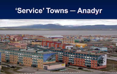 |
But there are different kinds of towns attached to the existing infrastructure corridors. I decided that we can call them “service towns.” One is Anadyr (Figure 11), the closest city to the Bering Strait, on our route. The population is about 12,000. Right now, it is functioning as a seaport, and thanks to our oligarch who is the owner of the Chelsea soccer club, you can see that Anadyr does not look too bad—quite attractive. It was absolutely different ten years ago, believe me. You would not have seen such colors; you would not have seen such buildings.
Another service town is Tiksi, on the Northern Seaway, on the coast of the Arctic Ocean. The population is 5,700 people. During this recent time, with perestroika and all these troubles, we nearly lost our Northern Seaway, and at the end of the 20th Century, we nearly thought that these towns would die. There was no transport, starting every Autumn, to bring in any goods; we had only summertime in which to do it. Otherwise, the only way to reach it was by plane, or sometimes by helicopter. And to bring in fuel, for example, by plane—you can imagine what the price for this fuel is!
But now, things have become better. The state is really paying attention to the Arctic, and there is even a program for building special Arctic vessels, including one nuclear-powered icebreaker with a capacity of 60MW; another icebreaker has a power capacity of 110MW.
|
FIGURE 12 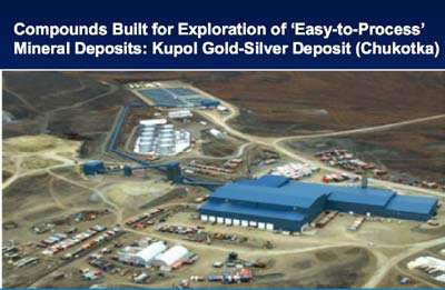 |
And the third kind of settlement is really very interesting. This is the area of a gold and silver deposit, named Kupol (Figure 12). The deposit is being developed by the Kinross gold company, together with the Chukotka government: 25% Chukotka government, and 75% Kinross company. In fact, gold deposits are more or less easy to process. What does that mean? The enrichment of the ore is mostly mechanical, so the processing factory is not very big.
What do they do? They build a compound, really in the middle of nowhere. This compound has a capacity to employ 500 people, and they develop this deposit, working in shifts. Five hundred stay there for one month, and they have everything in sight: shops, fitness centers, tennis courts, whatever. Even entering the compound, people used to take off their shoes! It’s a good example: What’s good for the people, is good for the company. The problem is, in such a case, the entire work of this mine is planned to last for 12 years. They will work for 12 years, then say good-bye, and we will see just garbage left in this area.
They have built a small airport, and there are regular flights. Right now, everything looks just perfect. But they can afford it, because right now, they told me that the cost of [producing] gold is a bit more than EU300 per ounce. You can imagine: The last price in New York was $1,300 per ounce. Quite a difference.
Infrastructure Corridors
|
FIGURE 13 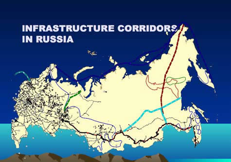 |
|
FIGURE 14 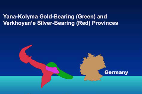 |
Let us go back to our plans. Figures 13 and 14 are really important for understanding what we’re going to do. The green indicates silver in this province, and the red shows gold and silver in this province. Look at these provinces, in comparison with the size of Germany! So, maybe there is some sense in building a railway!
So, what is the conclusion? To secure the success of such a transport infrastructure corridor, we have, first of all, to analyze how the existing resources are distributed, along the route of this corridor. Also, we have to try—it is not very easy, but such work is being done by the United States Geological Survey, and some work has been done by the Russian Geological Survey—to evaluate the distribution of undiscovered mineral resources. Because not all the areas have been studied in great detail; there is still a lot to be found. And we have to have at least an estimation.
Another task is to say: Okay, right now we have this distribution of resources. What do we want to achieve, after building the infrastructure corridor?
I can assure you that there are no unemployed people along the entire route from the Trans-Siberian Railroad to Anadyr: The density of the population is too low. And, in fact, if we build, we will have to bring people there. We have to motivate people to go to these cold, sometimes unpleasant, places. But we have to know, for ourselves, what do we want to achieve? How will the distribution of resources change, with this infrastructure corridor?
There is this, too. As you remember, I mentioned twice, about the Trans-Siberian Railroad, that even before the completion of the whole railway, separate parts of it were working. We have to find a way for separate parts of the infrastructure corridor to work before completing the whole corridor, from, for example, Khabarovsk to Alaska.
By the way, right now we are trying to develop a project under the umbrella of the Asian Pacific Economic Cooperation forum (APEC), and the project sounds very similar to this task. We are trying to establish a project, where we will analyze the distribution of existing resources, and recommend to the governments, directions for international infrastructure corridors.
In fact, a lot of things on this route are related to mineral resources. And very often, we can hear that some metal is nearly exhausted, that in five years we will not have it. It is not true. The radius of the Earth is 6,300 kilometers. Right now we work only on the surface. We don’t go any deeper than 400 meters—that is the maximum. In Germany, you have some uranium shafts to a depth of 2.6 km. Also, on top of them there is a big “refrigerator,” because the temperature 250 meters below is about 60°C. In the Republic of South Africa, we have shafts 4 km deep. There is a lot to be found. We need common sense to solve these tasks.
Maybe you have read Tom Clancy’s Debt of Honor. The intrigue is that Japan is hungry for resources, so they build a co-op, ruin the American economy; they are going to fight for Russian resources to build Japan’s empire in the Far East of Russia, and so on. Of course, it is fiction.
But if we unite, if we join our efforts, instead of trying to fool each other, we can make this work, we can develop. And the benefits will be not just for Russia, but for the whole world. Because Russia at the moment has a great stock of mineral treasures.
|
FIGURE 15 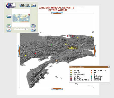 |
In conclusion, I would like to show you a product which we developed in 2006 (Figure 15). It is a kind of database, or encyclopedia, of the largest mineral deposits in the world. At this stage we had 1,244 deposits in this database, which is less than 1% of the known deposits in the world.
But the resources in these deposits, for different commodities, account for approximately 65-70%, even up to 80%, of known worldwide reserves. And you can see the different deposits. This one is the one I told you about—Kupol. We can click on it, and we’ll have data. Kupol, Chukotka, and so on.
You can see what we have here, on the route of the suggested infrastructure corridor. Of course we have gold; we have tin, tungsten, molybdenum, base metals, lead, zinc, copper. Actually, nearly all the minerals. And here we show just the largest, really largest, world-class deposits. And approximately 50% of the deposits shown here are still not developed. Because it is relatively easy to extract gold and silver; but to extract base metals, we need a huge factory, like in Norilsk. And Norilsk, as I told you, has a population of more than 100,000. All of Yakutia, which is bigger than the whole of Western Europe, by area, has a population of 950,000. That’s a lot, for such a place.
This software is published as a CD, and I will leave it for the Schiller Institute. Maybe it will be of use!